


LL34 Faveyrolles

alainandrejoly
User
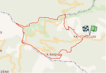

Length
12.6 km

Max alt
1058 m

Uphill gradient
642 m
Km-Effort
21 km

Min alt
512 m

Downhill gradient
641 m
Boucle
Yes
Creation date :
2016-10-30 00:00:00.0
Updated on :
2016-10-30 00:00:00.0
4h38
Difficulty : Medium

FREE GPS app for hiking
 SityTrail
IGN / Geographical institutes
SityTrail Plus
The world is yours!
About
Trail Walking of 12.6 km to be discovered at Occitania, Gard, Les Plantiers. This trail is proposed by alainandrejoly.
Description
30/10/2016
Faveyrolles - Le Pas - col de l'Espinas
Positioning
Country:
France
Region :
Occitania
Department/Province :
Gard
Municipality :
Les Plantiers
Location:
Unknown
Start:(Dec)
Start:(UTM)
555185 ; 4884311 (31T) N.
Comments